Harga Paling Murah Gps garmin 78s
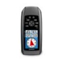
GPS GARMIN 78S
Negara Asal: Taiwan
GPSMAP 78S ini adalah generasi baru pengganti GPS Legendaris 76 series. Seperti halnya type 76, GPS ini juga waterproof dan bisa mengapung dia air.
Dilengkapi dengan 3 axies kompensator kompas, membuat arah yang ditunjukan selalu tepat walaupun GPS dalam keadaan berhenti. GPS ini juga sudah dilengkapi super sensitif sensor, sehingga mampu menangkap satelit dengan cepat dan akurat walaupun di medan yang banyak halangan. GPS ini juga dilengkapi koneksi wireless sehingga kita bisa sharing data ke GPS yang lain.
Physical & Performance:
Unit dimensions, WxHxD: 2.6 " x 6.0 " x 1.2 " ( 6.6 x 15.2 x 3.0 cm)
Display size, WxH: 1.43 " x 2.15 " ( 3.6 x 5.5 cm) ; 2.6 " diag ( 6.6 cm)
Display resolution, WxH: 160 x 240 pixels
Display type: transflective, 65-K color TFT
Weight: 7.7 oz ( 218.3 g) with batteries
Battery: 2 AA batteries ( not included) ; NiMH or Lithium recommended
Battery life: 20 hours
Waterproof: yes ( IPX7)
Floats: yes
High-sensitivity receiver: yes
Interface: high-speed USB and NMEA 0183 compatible
Maps & Memory:
Basemap: yes
Preloaded maps: no
Ability to add maps: yes
Built-in memory: 1.7 GB
Accepts data cards: microSDâ „ ¢ card ( not included)
Waypoints/ favorites/ locations: 2000
Routes: 200
Track log: 10, 000 points, 200 saved tracks
Features & Benefits:
Automatic routing ( turn by turn routing on roads) : yes ( with optional mapping for detailed roads)
Electronic compass: yes ( tilt-compensated, 3-axis)
Touchscreen: no
Barometric altimeter: yes
Camera: no
Geocaching-friendly: yes ( paperless)
Custom maps compatible: yes
Photo navigation ( navigate to geotagged photos) : yes
Outdoor GPS games: no
Hunt/ fish calendar: yes
Sun and moon information: yes
Tide tables: yes
Area calculation: yes
Custom POIs ( ability to add additional points of interest) : yes
Unit-to-unit transfer ( shares data wirelessly with similar units) : yes
Picture viewer: no
Garmin Connectâ „ ¢ compatible ( online community where you analyze, categorize and share data) : yes
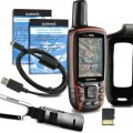
Isi kemasan :
GPSMAP 78s
Wrist strap
Memory 2 GB + Map Indonesia
USB cable
Manual
Garansi 1 Tahun
- Nama:erik estrada
- Username:nusatama
- Reputasi:
- Terdaftar :14-09-2015
- Status:

- HP:0812-XXXX-XXXX Lihat
- Cek Penipu atau Bukan
- YM:
- Alamat:JL.H.Sapri No.32 Pondok Aren ( Tangerang selatan )
- Kota:tangerang
- Provinsi:Banten
Nusatama Bergerak di bidang alat-alat survey dan navigasi, seperti : Total Station, Theodolite, Automatic Level, Binoculars, Kompas, Clinometer, Altimeter, Suunto Tandem, Waterpass, GPS, Perahu Karet dan Alat-alat Geologi.
survey instrument atau alat ukur dan pengadaan alat - alat geologi serta GPS, Kami disini sebagai supplier survey instrument/ alat survey tanah atau bangunan, alat survey telekomunikasi, alat survey geologi atau mining, coal, dan alat survey lainnya diantaranya :
Total Station, digital theodolite, automatic level / waterpass, distometer, Gps, binoculars, kompas, clinometer, altimeter, suunto tandem dan alat-alat geologi.
Produk Survey Instrument dan tool/ alat geologi yang kami jual telah ditunjang dengan berbagai merk yang sudah terkenal dan telah diakui keberadaanya didunia survey seperti : nikon, sokkia, topcon, south, horizon, bushnell, brunton, suunto, leica, estwing, trimble, magelan dan thales.
Menjual gps bergaransi dan resmi : gps garmin sebagai best seller mampu menghadirkan kelebihan-kelebihan Global Potition System dengan aplikasi mudah terpercaya.
thales / magelan, trimble, south, spectra untuk type gps mapping dan geodetic bagi anda yang bergerak dibidang pertambangan/ minning, pertanahan, geologi, geodesi, metreologi dan konsultan.
Kami melayani untuk perorangan dan perusahaan ! bagi kami harga kompetitif adalah milik bersama dan permintaan pasar adalah yang utama.
Harga jual kami bersaing & BEBAS BIAYA KIRIM ( JAKARTA) , dijamin !
PASTIKAN BARANG YANG ANDA BELI BERGARANSI RESMI !
JANGAN SAMPAI ANDA SALAH PILIH...
Info dan harga terbaik :
Nusatama Bergerak di bidang alat-alat survey dan navigasi, seperti : Total Station, Theodolite, Automatic Level, Binoculars, Kompas, Clinometer, Altimeter, Suunto Tandem, Waterpass, GPS, Perahu Karet dan Alat-alat Geologi.
- Kunjungi Tips Belanja Aman
- Jangan tergiur harga murah, usahakan tidak melakukan transer langsung.
- Gunakan rekening bersama. Lebih baik kehilangan uang 5 atau 10.000 daripada tertipu.

Leave Comment