Gps 62s Murah Call :085694937489 / 081296514532
Garmin GPSMap 62S
Spesifikasi :
Physical & Performance:
Unit dimensions, WxHxD: 2.4" x 6.3" x 1.4" (6.1 x 16.0 x 3.6 cm)
Display size, WxH: 1.6" x 2.2" (4.1 x 5.6 cm); 2.6" diag (6.6 cm)
Display resolution, WxH: 160 x 240 pixels
Display type: transflective, 65-K color TFT
Weight: 9.2 oz (260.1 g) with batteries
Battery: 2 AA batteries (not included); NiMH or Lithium recommended
Battery life: 20 hours
Waterproof: yes (IPX7)
Floats: no
High-sensitivity receiver: yes
Interface: high-speed USB and NMEA 0183 compatible
Maps & Memory:
Basemap: yes
Ability to add maps: yes
Built-in memory: 1.7 GB
Accepts data cards: microSD™ card (not included)
Waypoints/favorites/locations: 2000
Routes: 200
Track log: 10,000 points, 200 saved tracks
Features: Automatic routing (turn by turn routing on roads): yes (with optional mapping for detailed roads)
Electronic compass: yes (tilt-compensated, 3-axis)
Touchscreen: no
Barometric altimeter: yes
Camera: no
Geocaching-friendly: yes (paperless)
Custom maps compatible: yes
Photo navigation (navigate to geotagged photos): yes
Outdoor GPS games: no
Hunt/fish calendar: yes
Sun and moon information: yes
Tide tables: yes
Area calculation: yes
Custom POIs (ability to add additional points of interest): yes
Unit-to-unit transfer (shares data wirelessly with similar units): yes
Picture viewer: no
Garmin Connect™ compatible (online community where you analyze, categorize and share data):
Paket sudah termasuk :
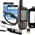
GPSMAP 62s
Map Indonesia
Memory MicroSD 2GB + adapter
Carabiner clip
USB cable
Quick start manual
- Nama:erik estrada
- Username:nusatama
- Reputasi:
- Terdaftar :14-09-2015
- Status:

- HP:0812-XXXX-XXXX Lihat
- Cek Penipu atau Bukan
- YM:
- Alamat:JL.H.Sapri No.32 Pondok Aren ( Tangerang selatan )
- Kota:tangerang
- Provinsi:Banten
Nusatama Bergerak di bidang alat-alat survey dan navigasi, seperti : Total Station, Theodolite, Automatic Level, Binoculars, Kompas, Clinometer, Altimeter, Suunto Tandem, Waterpass, GPS, Perahu Karet dan Alat-alat Geologi.
survey instrument atau alat ukur dan pengadaan alat - alat geologi serta GPS, Kami disini sebagai supplier survey instrument/ alat survey tanah atau bangunan, alat survey telekomunikasi, alat survey geologi atau mining, coal, dan alat survey lainnya diantaranya :
Total Station, digital theodolite, automatic level / waterpass, distometer, Gps, binoculars, kompas, clinometer, altimeter, suunto tandem dan alat-alat geologi.
Produk Survey Instrument dan tool/ alat geologi yang kami jual telah ditunjang dengan berbagai merk yang sudah terkenal dan telah diakui keberadaanya didunia survey seperti : nikon, sokkia, topcon, south, horizon, bushnell, brunton, suunto, leica, estwing, trimble, magelan dan thales.
Menjual gps bergaransi dan resmi : gps garmin sebagai best seller mampu menghadirkan kelebihan-kelebihan Global Potition System dengan aplikasi mudah terpercaya.
thales / magelan, trimble, south, spectra untuk type gps mapping dan geodetic bagi anda yang bergerak dibidang pertambangan/ minning, pertanahan, geologi, geodesi, metreologi dan konsultan.
Kami melayani untuk perorangan dan perusahaan ! bagi kami harga kompetitif adalah milik bersama dan permintaan pasar adalah yang utama.
Harga jual kami bersaing & BEBAS BIAYA KIRIM ( JAKARTA) , dijamin !
PASTIKAN BARANG YANG ANDA BELI BERGARANSI RESMI !
JANGAN SAMPAI ANDA SALAH PILIH...
Info dan harga terbaik :
Nusatama Bergerak di bidang alat-alat survey dan navigasi, seperti : Total Station, Theodolite, Automatic Level, Binoculars, Kompas, Clinometer, Altimeter, Suunto Tandem, Waterpass, GPS, Perahu Karet dan Alat-alat Geologi.
- Kunjungi Tips Belanja Aman
- Jangan tergiur harga murah, usahakan tidak melakukan transer langsung.
- Gunakan rekening bersama. Lebih baik kehilangan uang 5 atau 10.000 daripada tertipu.
Related Products
4.850.000
12.500.000
6.500.000
2.950.000
25.800

Leave Comment